Shenfield - Good, Quiet Roads

Windmill at Mountnessing (5 km from Shenfield)
Getting There on the Elizabeth Line
Trains run every few minutes from Paddington to Shenfield. Coming from the west, I chose to stay on the Abbey Wood train (where I had found a quiet spot in the first carriage) and change at Whitechapel. The recorded announcement urges passengers travelling to Shenfield to change at Stratford where Greater Anglia provides a non stopping service to Shenfield. If you are using a Freedom Pass, ignore this advice - the Freedom Pass is not valid beyond Harold Wood. You would need an extension ticket or risk a fine. In any case the time saving is not great after you have negotiated the stairs or lift (at the London end of the platform).
I will probably reserve my journeys to Shenfield for weekends; for me, living in West London, it can be difficult to fit in a ride of more than about 60 km and get back to Paddington to change trains before the 4 pm deadline for non folding bikes.
Leaving Shenfield
“What’s in Shenfield?” I have been asked by more than one person. “No idea, it’s just the end of the line,” is my somewhat uninformative reply.

Leaving Shenfield Station along Hutton Road
After leaving Shenfield station, the route continues straight ahead (left, immediately right) into York Road as Hutton Road (A129) turns right. It’s a right turn at a junction into Werrin Road, soon crossing the A1023 Shenfield Road into Halls Lane to pass the church of St Mary the Virgin, the first on this route with a distinctive white weatherboarded belfry. More here on this Grade II listed building.

St Mary the Virgin Church, Shenfield
Out to Matching Tye
From here the route continues to Doddinghurst. Although I rode this on a weekday morning, there was very little traffic, so refreshing! It’s a left turn into Days Lane by the Doddinghurst village sign on Peartree Green.


The route soon turns right into Dagwood Lane; it’s then a left turn at a junction into Church Lane, followed by a right turn into Stocks Lane. This meets Blackmore Road where the route turns right. In the near distance is a distinctive and very delicate looking tower; soon after leaving the housing, the route passes this tower which is identified on the Ordnance Survey (OS) map as a radio tower. David Neale on Flickr states: “The structure is now naked compared to the amount of Dish Aerials it supported in the long distance microwave days. Of course satelite and fibre optic technology have taken over.” For me, this was a familiar landmark when I rode a number of 100 km Audax events in this area some years ago.
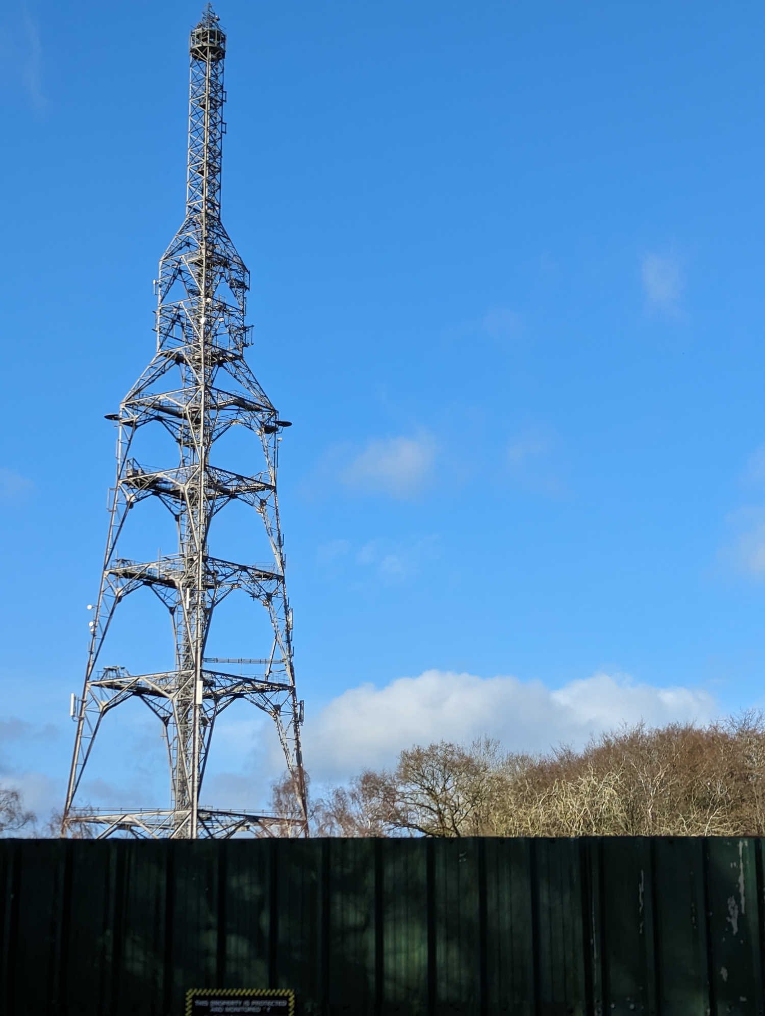
Radio Tower at Kelvedon Hatch
Shortly after the tower the route turns left into School Road, then right into Chivers Road. It’s then a left turn on to the Ongar Road, still very quiet with little traffic. I turned into the road to Standon Hall Farm to take a photo of the Church of St Peter and St Paul Standon Massey, which has the distinctive white weatherboarding seen on the church at Shenfield. This weatherboarding echoes the material on some houses in this area of Essex.

Church of St Peter and St Paul Standon Massey
The route continues along the Ongar Road which bears left into Standon Road and joins the A128 to continue in the same direction for a short distance to a roundabout where it is a right turn to continue on the A128. It’s not far to a left turn into The Borough which leads to Greensted Road; this becomes Blake Hall Road where there is a real treat for railway enthusiasts: the old Blake Hill station with its platform clearly visible from the road bridge and the substantial station building which is now a large private house.


Mashams thatched cottage
The route continues north to cross the busy A414 Epping Road into Lower Bobbingworth Green before turning left at a junction into Stony Lane, then shortly right into Moreton Road. Continuing to Pedlars End and Bridge Road, the route turns left in Moreton to take Harlow Road for a short distance. Leaving Harlow Road, the route continues ahead, north, to a left turn into Church Road. At a minor crossroads it’s straight ahead into Workers Lane before a right turn into Faggotters Lane. I spotted a thatched cottage just beyond this turn and went briefly off route to take a photo of Mashams, with a postbox in the garden.
Returning to Faggotters Lane I continued to a ford, which I am pleased to say was very shallow even though the weather had been really wet and I was to encounter a flooded road later in the ride.
At the end of Faggotters Lane the route bears left into Housham Road and then right onto Harlow Road towards Matching Tye. This was a bit of a loop which I put into the ride to pass a windmill - which I missed. Must look more carefully next time!
This section of the route ends in Matching Tye where I met some other cyclists; one of them commented on how good the road surfaces are in Essex compared with Hertfordshire where he lived. They are certainly better than in Buckinghamshire and Berkshire, near where I live on the other side of London. The group soon headed off, keen to beat the rain forecast for the afternoon.

House in Matching Tye
On a day with time to spare, the Fox Inn provides a good stopping point for lunch.
Matching Tye to Shenfield
The route continues along Matching Tye Road, bearing right at the cricket ground in Matching Green to take Potash Road and shortly after Anchor Lane to the right. After about 3.7 km the route takes a right turn into Green Hill Road, dropping gently towards Abbess Roding for a right turn into School Lane shortly after the church and the village sign.

Abbess Roding - seat and village sign, with church in background

I’d just ridden through this!
As School Lane met the B184 Dunmow Road for a right turn, I met the first of the promised showers. Pressing on, I turned left into School Lane, pleased that I was making good progress and hoping to get back to Shenfield before any heavy rain. Just over 1 km along School Lane I was confronted with a section of road that was flooded from verge to verge. I don’t like riding through water that is so deep that I can’t see the surface because potholes and other nasties could be lurking. But, I consoled myself, my Airnimal Joey has strong wheels with 37 mm Marathon Plus tyres: I’d give it a go. I wasn’t prepared for the resistance that flood water puts up and as my front wheel dropped into a pothole I put my left foot down for a moment to steady myself before continuing. Fortunately my Lake CX145 boots kept the water out and my feet stayed dry. A motorist towards me asked how deep the water was and when I told him that I had ridden through it, he said, “Well done!” and took his chance.

The route continues into Birds Green and bears right along Dukes Lane and Beech Road into Willingale. Left into Wood Lane, right into Spains Hall Road for a brief stop by Spains Hall Farm to don the Castelli Idro waterproof jacket. Right at Pigstye Green into Norton Heath Road and left into Willingale Road. Just before Willingale Road meets Norton Heath Road there’s a plant hire business on the left; as I turned left then shortly right at Norton Heath Cafe I saw quite a number of workers in hi viz jackets in the cafe. Turning left to pass the cafe building I rode past a number of cars that had definitely seen better days before crossing the A414.
Fingrith Hall Lane continues from the cafe, across the A414, into Blackmore for a left turn along The Green, followed by a right turn into Ingatestone Road. This continues to Mountnessing Road which becomes Thoby Lane to cross the Roman Road (B1002) just after the windmill where dog owners were walking their dogs in the rain. A left turn took me into Arnolds Farm Lane which I had checked out on Google Maps; it had been resurfaced recently and was a good route into Lower Road and Wash Road which were the only busy parts of this ride. I was relieved to turn right into Woodland Avenue and cycle through residential streets to meet the railway on my right as I rode along Long Riding Avenue and Alexander Lane back to Hutton Road and Shenfield station.
As I showed my Freedom Pass at the barrier, I was informed that the only platforms I could use were 5 and 6 for the Elizabeth Line as “Freedom Passes are not valid on OUR trains.” It was only a short wait before the Elizabeth Line train left for all stations (that’s 18) to Paddington.
The Route
Route map for Shenfield Matching Tye Retn 63km on plotaroute.com
Refreshments
Fox Inn at Matching Tye - I’ve eaten there on a ride with Central London CTC. Accommodation, generally good reviews
Norton Heath Cafe - very good reviews, I did not stop here because of time