Taplow Boveney Eton Windsor Taplow 30 km
A short ride with much to see
A short ride, much of the route on quiet roads or off-road. One climb towards the end, with an option to avoid it by using the cycleway alongside the A4.
Taplow station is one of my favourites because it preserves most of its original features but with lifts and modernised toilets. The station is served by the half hourly Reading trains. Elizabeth Line services terminating at Maidenhead do not stop at Taplow.
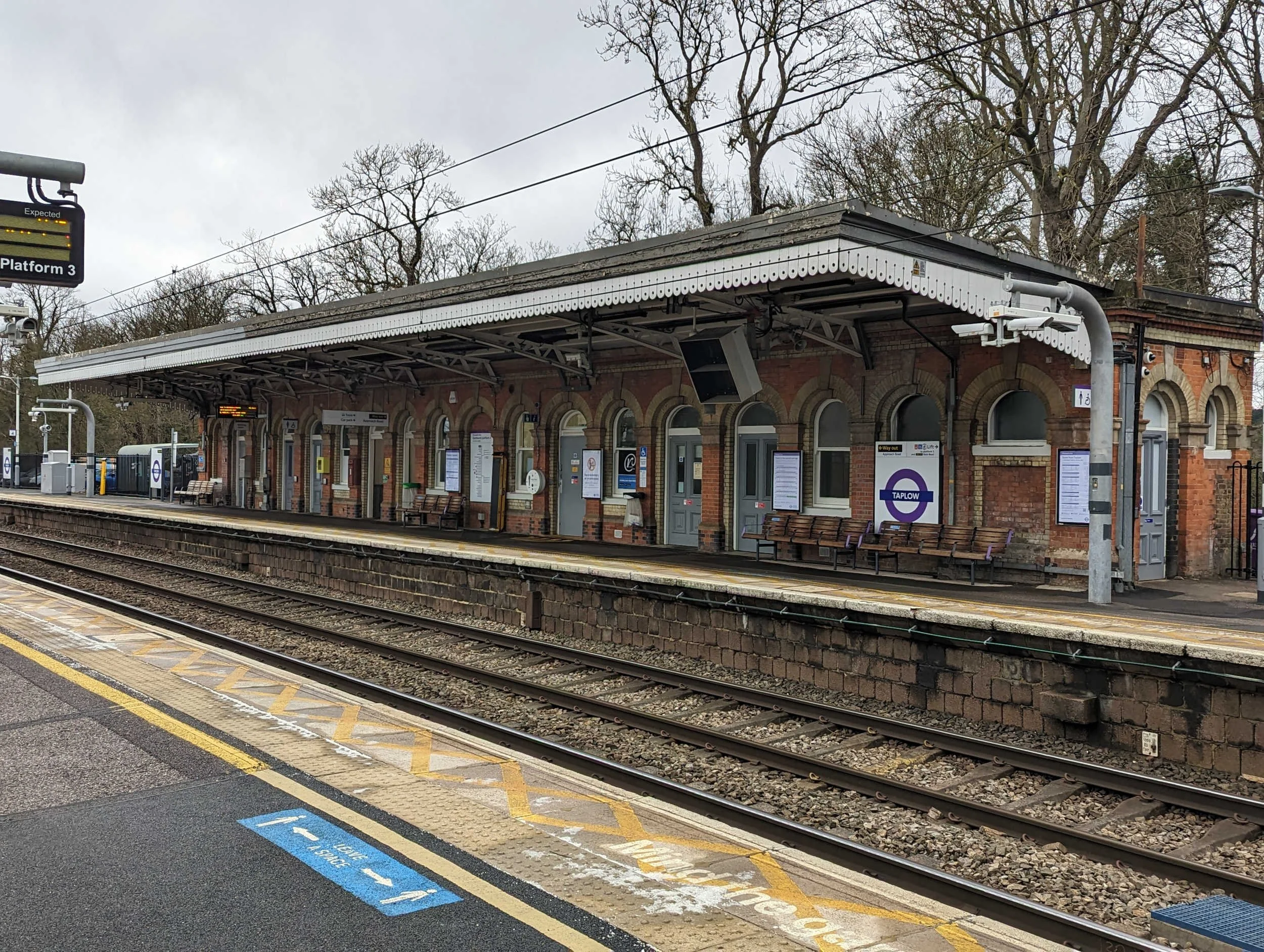
Taplow Station retains many original features
As there’s much to see on this short ride, this post has so many photos that I’ve decided to put the map before most of the description so that you can get on and ride if you wish.
Route map for on plotaroute.com
Taplow Station to Dorney Court
Turning right from the station, the route meets Station Road where it’s a right turn to pass under the bridge. The dip in the road here collects water after heavy rain but I’ve always found that I can get through on the London side. The route soon meets the A4 at traffic lights, where it’s right and immediately left, signposted to Dorney, into Marsh Lane.


Click for larger view of each image.

Passing Jubilee Way towards Eton and Windsor
After less than 1 km the route passes a small car park and the Jubilee Way which runs between Maidenhead to the west and Eton and Windsor to the east.
The route continues on-road, over the M4 motorway, to a left hand bend in the road with the entrance to Dorney Lake on the right.
The route now continues into Court Lane.
Shortly, there’s a tempting right turn to the tiny beautiful 12th century church of St James the Less. As I was passing one of the buildings next to it, I saw a woman with a clipboard leading two people and stopped to ask her what the buildings were. She explained that they were part of Dorney Court and were the stables, now the Coach House and used as a wedding venue. Curiosity satisfied, I returned to the road, turned right and continued a short distance before making another diversion into Dorney Court towards the garden centre and cafe.


The cafe at Dorney Court garden centre is probably best enjoyed if you are on a cycle ride with one or more companions as there does not appear to be anywhere to secure a bike with a padlock.
Dorney to Eton via Boveney
The route continues back into Court Lane towards the junction for a right turn through Dorney. Although this is quite a picturesque village, I’ve often found that this short section of the ride can be spoiled by cars travelling excessively fast. However, soon after the cattle grid at the end of the village the route takes a right turn off the busy B3026 to take a quiet narrow road signposted to Boveney.
The road passes Boveney Court Farm on the left and becomes Lock Path, designated as a bridleway. Shortly before a gate (which cycles can pass to the left), I glimpsed St Mary Magdalene’s Church on the right, across a field.

St Mary Magdalene Church seen from the bridleway
Continuing, the route passes Boveney Lock to the right. There’s no cycling along the towpath, with the bridleway/ cyclepath continuing on a clearly marked route.

Boveney Lock
At a signpost by railings the route turns left towards Slough but only as far as a right turn, just before the road, along a cyclepath parallel to the road but separated by a hedge.


Click for larger view.
Some large tree trunks have been laid along the cyclepath, emphasising separation from the road. Some of these have distinctive bark patterns, somewhat eroded by weather and time.

Turn left into Meadow Lane
After about 1 km the cyclepath turns to the right alongside allotments and railway arches; these support the track from Slough to Windsor and Eton Central station, which is served by a two car diesel service running every 20 minutes; the journey takes 6 minutes. At the end of this cyclepath the route takes a left turn into Meadow Lane and shortly another left turn into South Meadow Lane towards the buildings of Eton College.
Eton to Windsor
South Meadow Lane become Keats Lane to pass the Lower Chapel of Eton College and the Natural History Museum; I had not realised that Eton College has a natural history museum and noted that it is open on Sunday afternoons - must visit.


The route continues to traffic lights where it is a right turn into The Street which becomes High Street Eton. Several shops provide for the tailoring needs of the College.

Weatherill Eton Tailors
Through Windsor, past the Castle
Continuing south along Eton High Street, the route takes Thames Street to cross the bridge over the Thames with views of Windsor Castle ahead. There are places to stop for coffee but beware cycle thieves! After crossing the bridge, the route continues straight ahead through traffic lights, still Thames Street, with views of the castle.


Thames Street bears right, then left, climbing into the High Street with the shopping centre on the right (and the entrance to Windsor and Eton Central station) and the castle gates on the left a little further on.

Looking left towards the castle gates
Turning right at a mini roundabout the route continues along Victoria Street (with public toilets in the car park on the left); Victoria Street becomes Clarence Road. The route turns right at traffic lights into Alma Road and continues over traffic lights at Arthur Road straight ahead to a car park. Here I turned right and rode through the coach park until I saw the bandstand on my left; I rode (through Alexandra Gardens) past the bandstand to a cyclepath to meet Barry Avenue and pass under the railway.

Cycleway under the railway arches
The route then passes Windsor Leisure Centre to continue straight ahead (as the road turns sharp left - care needed!) to pass under the A332 dual carriageway.

Cycleway under A332 road - just past Windsor Leisure Centre
Windsor Cycling Hub
Following left into Clewer Court Road and Mill Lane, the route arrives at the Windsor Cycling Hub which is open on Saturday mornings between 11 am and 1 pm for people to take their bikes for repair or advice. The Cycling Hub runs regular rides for beginning cyclists with a progression over each month. The Cycling Hub’s key objective is “to increase the accessibility of cycling in and around Windsor – helping to make it a reality for all.” For futher information, please visit the charity’s website and tell anyone who might want help with their bike or in gaining confidence to ride on the road. The Cycling Hub is based at the Swan pub where a sign urges passers by to come in - it’s warm inside!

The final part of the route is on busier roads; inexperienced or nervous riders could return to Windsor and take the train to Slough to join the Elizabeth Line.
Windsor, Coningsby, Bray
The route continues along Parsonage Lane and then turns right at a junction onto Dedworth Road. It’s just over 2 km to Oakley Green Road where the route left for about 3 km. Just past the Fifield Polo Club you will be able to see a tribute to the late Queen and Prince Philip, two large busts that look rather sad, at least to me.
Passing the left turn to Fifield Lane, the route soon turns right along Coningsby Lane.

Approaching Grove Barn in Coningsby
Passing Coningsby Farm, the route traverses numerous potholes to meet Fifield Road for a left turn to cross Windsor Road (A308), right and immediately left, into Monkey Island Lane. This crosses the M4, becoming Old Mill Lane and entering Bray village via a well signed route for cyclists. The route soon meets the B3028 Bray Road, leading into Maidenhead. At a roundabout the route takes the second exit into Oldfield Road, passing under a railway bridge to a right turn opposite the SK Express convenience store into Oldacres. This is signed as part of the NCN. It’s then a left turn, followed by the second right turn into Horseguards Drive to pass through barriers and turn left along Guards Club Road.

Through the barriers to turn left in front of the building ahead
And finally back to Taplow - choice of routes
The route meets the A4 at a roundabout with the bridge on the right. Here it turns right over the bridge. Two options: to avoid riding any further on the A4 but at the cost of some climbing, read on. To avoid the climb, skip to the following paragraph.
Immediately after the bridge, it’s a left turn into Mill Lane and the Taplow Riverside development, taking care to avoid a large pothole as you turn off theg A4 into Mill Lane; this pothole seems to have been there for ever, perhaps with neither the Local Authority or the developers taking responsibility. The route continues through the development, turning right by a feature waterwheel to climb along Mill Lane towards Berry Hill. Almost at the top of the climb of Berry Hil, the route turns right along Rectory Road, past the Oak and Saw pub on the right and the church on the left to meet Boundary Road.

Continue past the Oak and Saw pub on the right and the church on the left
It’s then gently downhill to a right turn into Station Road and a final right turn into Approach Road for Taplow Station. When I rode this route, I was lucky to arrive at the station with less than a minute to spare to catch the train. One minute later and I would have had to wait almost half an hour for the next Reading train because services starting from Maidenhead do not stop at Taplow.
To avoid the climb, continue on the A4, using the cycleway to pass the BMW dealer and the Miller and Carter steakhouse and turn left along Approach Road to the station. All flat but next to heavy traffic.